Frenchman Bay Atlas Project
This Atlas was produced at College of the Atlantic but its creation was motivated by the formation of the Frenchman Bay Partners, a group seeking a sustainable economic and ecological future for the Frenchman Bay region (www.frenchmanbaypartners.org).
The PDF Atlas references the sources of geographical data used in the atlas. The Online Atlas is a GIS mapping program that allows the user to interact and combine the various data layers in unique ways, unlike the paper maps.
Version 1.0 August 2012
Edited by Alex Brett, Chris Petersen, and Gordon Longsworth ’91
Maps:
 Vinalhaven Suitability for Development Modeling Vinalhaven Suitability for Development Modeling
|
 MDI Suitability for Development Modeling MDI Suitability for Development Modeling
|
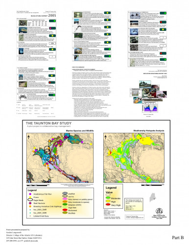 Taunton Bay Study Taunton Bay Study
|
 Downeast Acadia Watersheds, Islands and Bays Downeast Acadia Watersheds, Islands and Bays
|
Presentations: (hosted via Google Docs)
A Visual Analysis of Great Duck Island
Community Analyst for ArcGIS demo
 View the gallery of